Explained:Chilean Navy ”UFO”Video Aerodynamic Contrails,Flight IB6830
2014.11.11 チリ海軍がへりの赤外線ビデオで捉えたUFOという事で、世界中のメディアで話題になりましたが、正体はエアバス、中距離のツインジェット機であったという研究が紹介されています。
早くはフランスの分析機関IPACO(マクミンビル事件では論文紹介でお世話になりました。)が2015年11.26に論文を発表しています。
詳細はこのPDFをご覧ください。
http://www.ipaco.fr/ReportChileanNavyCEFAA.pdf
● またMetabunk-OrgというブログでもIPACOの分析を参考にした解析論文が掲載されています。
一部を掲載しますので、関心のある方はサイトから詳細をご覧ください。
https://www.metabunk.org/explained-chilean-navy-ufo-video-aerodynamic-contrails-flight-ib6830.t8306/

Mick WestAdministratorStaff Member
If you are short on time, then I made a one minute video explaining this:
Source: https://www.youtube.com/watch?v=2bFfuIidCK0
Background: Infrared footage from the Chilean Navy appears to show some kind of flying object that briefly leaves a trail behind it.
http://www.huffingtonpost.com/entry..._us_586d37bce4b014e7c72ee56b?lciacn1ruwjkmx6r (Full footage can be seen here)
This looks like a plane, flying away from the camera considerably higher than the helicopter (somewhere around 15,000 to 25,000 feet), that briefly creates an aerodynamic contrail.
Based on analysis by @Trailblazer, @Trailspotter, myself, and others, There were only two planes possibly involved: IB6830 and LA330. The plane that initially seems to fit best is LA330, a two engined A320, which was reported to be climbing through 20,000 feet at that exact visual position at 14:01:39.
https://planefinder.net/flight/LXP330/time/2014-11-11T17:01:39 UTC/speed/15.00
While this seemed like a good fit just based on this overhead view, subsequent 3D analysis revealed that IB6830 (a four engined A340) is actually a perfect match. IB6830 left earlier, and was climbing out more to the south, nearer to the helicopter. At the time this was spotted (the very first sighting on the video, at 13:52:34) IB6830 was actually around 35 miles away. However it would very quickly get further away. By 13:57 IB6830 would be 65 miles away. This explain why it was not seen on radar (IB6830 was on radar, just not where they thought it was)
Initially I had to extract the data for the track from Planefinder, but then I located the FlightAware GPS track. Using this, multiple other examples of IB6830's departure, and the official departure charts, I was able to create a track in google earth using actual GPS coordinates (blue) and estimated positions (orange).
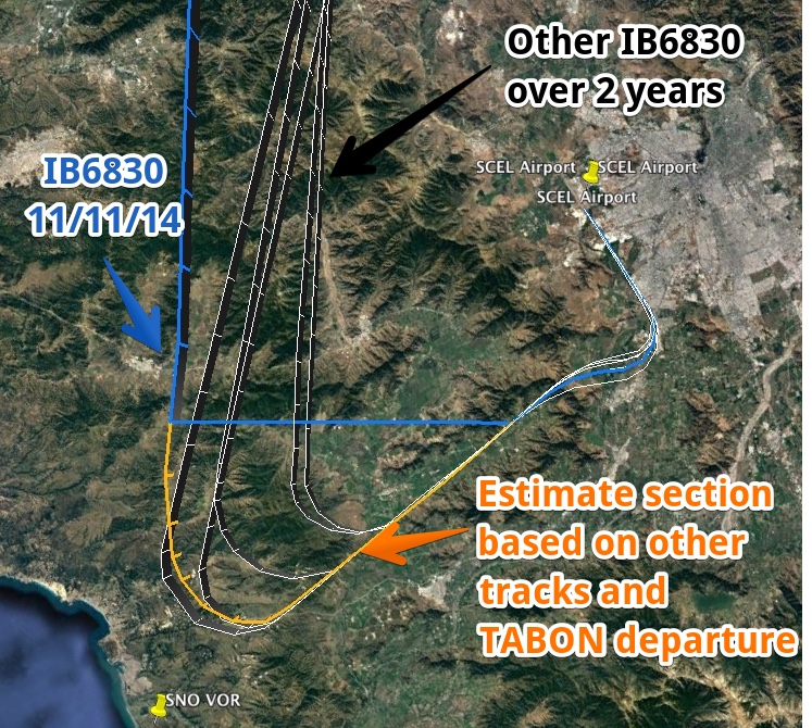
Since we have timestamped GPS locations, we can now geolocate IB6830 and LA330 in Google Earth, and create views of frames from the helicopter video using the coastline and mountains to get the exact heading.
IB6830 is in exactly the right position. We can position both the planes and the chopper precisely with the GPS data, match the camera direction from the wide shot, and the position of IB6830 then matches exactly.
Here's a video showing how it matches up:
Source: https://www.youtube.com/watch?v=Uoqxr6AI7VQ
The two large blobs are flared images from the heat of the engines (much smaller in reality). You can see this effect with some candles if you view them from a distance with an IR camera. I used the FLIR ONE to do this:
(Here's a video of the above experiment)
We can see how large the flares look at various stages of the path.
The flaring is more apparent if you look at it uninverted. The engines appear as two very bright lights
The aerodynamic contrail starts ands stop in a similar way to the trail in this video (not a "chemtrail" though, this just a regular aerodynamic contrail)
Source: https://www.youtube.com/watch?v=cjy0NcUCTEc
There are a few different relevant images from the video:
This is a close-up of the object early in the video:

This shows that the plane is banked at this point - i.e. it is turning to the right. This matches the part of the track for IB6830 where it turns to the north, based on the time.
Compare it with this video of a plane taking off. It is much closer, however at the end of the video you see the two engines tilted at about the same angle as the "UFO" while the plane turns right.
At one point (9:08) they switch between the IR camera and a regular (visible light) camera. you can see the trail qute distinctly. It looks very like a contrail.
Why is it showing up as warmer? Aerodynamic contrails are essentially clouds, and at this altitude they will be ice clouds, below below freezing. They show up as darkly colored for the same reason that other clouds in the scene show up dark. It's simply the camera adjusting the exposure for the very cold sky. The engines are small so they don't effect the exposure much (and hence they flare). So the net result is that anything warmer than radiation coming from clear sky will appear dark.
A few seconds later
It also seems a bit odd that there is very little change in the heading and elevation angles in the video. This becomes clear if you look at the angles and distances involved
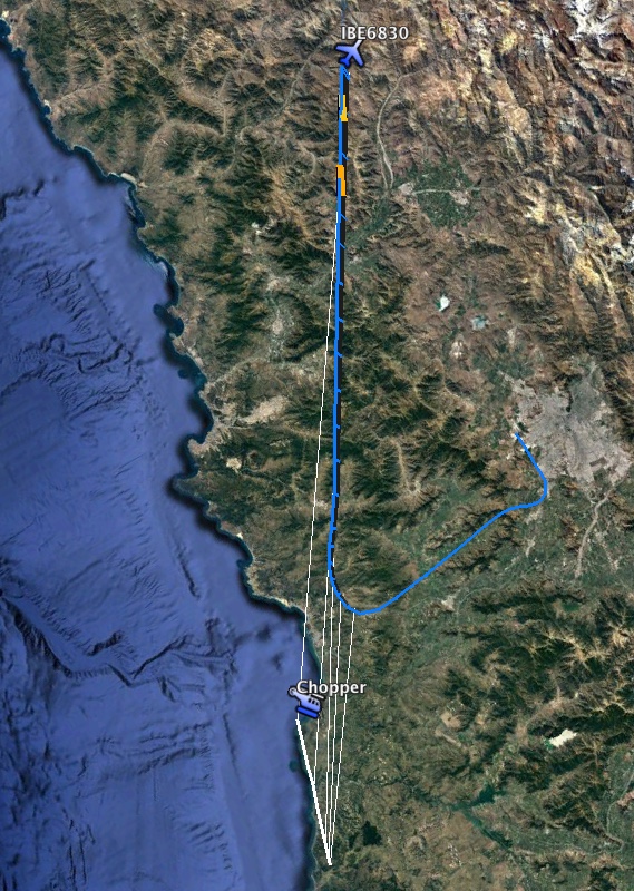
The thin white lines here connect the chopper and the plane at equal times, as you can see the heading angle between them does not change much.
The altitude of the plane varies from ~5000m to 9000m, while the distance varies from 70km to 170km, the chopper is about 1400m, we can draw a diagram to see the angles
As you can see there is very little change from the start (2.93°) to the end (1.94). Basically it should vary from about 3° to about 2° (appearing to be descending faster at the start)
[Note: this top post will be updated with information from the discussion below, so some of what follows may seem repetitive]
References: IPACO Report
@Kz.UFO現象調査会